The Downriver area’s aviation portfolio does not specifically point to the history of Detroit Metro Airport as the area’s lone flight server. We will not attempt to reconstruct its history here, as their website already has made fantastic use of available material to record their happenings. The smaller, private airports will be shown here.
Nan-Bar Airport, Flat Rock area
(Contributors: Brian Rehwinkel & Michael McMurtrey)
(Photos courtesy of airfields-freeman.com)
Nan-Bar Airport, which likely opened just after Hance Airfield in Ecorse Township in the early 1930s, was named for the daughters of co-owners Chet Brazer & Red Stultz. The 95 acres on which this airport was situated was specifically leased by the United States government (Navy division) and was located south of Vreeland Road and west of Cahill Road.
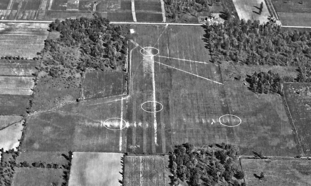
Also known as Flat Rock Field when first depicted on topography maps in 1942, Nan-Bar also had a specific World War II purpose: it would be one of 16 outlying Fields used to support flight training at Grosse Ile’s Naval Air Station. Instruction was also offered in short field landings, and the facility was always available in case of an emergency landing.
As was the case with Hance Airfield, Nan-Bar’s runways were grassy and short when compared with Grosse Ile’s. There were three runways total, with four circular areas marked off to depict landing targets for incoming aircraft. Most of the service buildings were located on the south end of the airport, closer to Gibraltar Road.
The facility’s service time for military purposes ended shortly after World War II, with Nan-Bar reverting to a small private airfield.
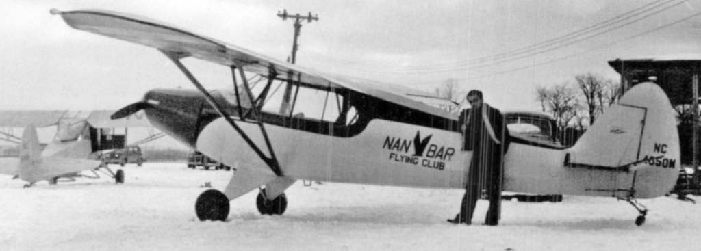
On a monthly basis, a gentleman named Robert Cornwell (shown above on right) would be piloted in an aircraft in collaboration with the Detroit Edison Company as an observer on line maintenance. He also did maintenance work on site as well as the painting of various aircraft.
It is believed that sometime in the 1950s, the airfield was reduced to the East-West runway only. It is also known to have survived as an active field longer than Hance, as operations continued there into at least the mid-1960s, although various technical guide books still listed it as late as 1974.
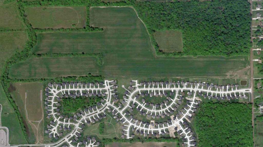
It is definitely known to have been abandoned by that time, with the last building on site being razed, possibly in the latter half of that decade. Currently, the area to the south of the former airport houses a modern subdivision. However, looking at the present day photo to the left (taken in 2010), traces of the former airport grassy runway still clearly exist.
Hance Airfield, Ecorse Township
Hance Airfield was located off Eureka Road, between Trenton and present-day Richmond Street, in the future territory of Southgate.
Very little concrete information exists about the specific uses of the facility, but its earlier operations were likely akin to a smaller version of today’s Grosse Ile Municipal Airport, although – as in the former Grosse Ile Naval Academy – Hance was likely as well prepared for wartime purposes. It has been said that Henry Ford once had an interest (or minor partnership) in the facility, although his memoirs do not confirm or deny this.
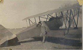
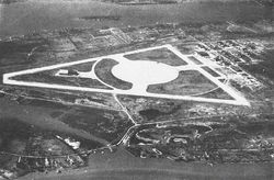
The earliest photo at the site, dated approximately 1930, is shown to the right with an unidentified pilot and his aircraft. Meanwhile, the first overhead snapshot dates from September 12, 1943 and shows a view looking north, courtesy of that year’s AAF Airfield Directory. The Hance facility was described as having three unpaved runways with a ramp on the north side.
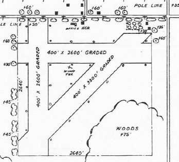
A subsequent directory was much clearer in its description: it profiled the airfield as a 160 acre square-shaped property, having three clay, loam, and sod runways: two of them were 2,600′, the largest being the 3,300′ northeast-southwest strip.
There were no concrete or asphalt runways, perhaps either due to the type of aircraft used or in recognition of maintaining low noise levels in the surrounding area.
The field contained two aircraft hangars – the largest being a 177′ x 30′ wood structure – and the field was described as being operated by private interests.
Unlike the Grosse Ile facility, it is apparent – due to lack of news items – that Hance was not called upon during wartime in a major sense, but may have resembled a smaller version of today’s Willow Run Airport in its waning days.
Sources are unsure as to Hance’s exact opening year, and the same uncertainty exists with regards to its closing year or reason for doing so. Some reports point to the facility being deactivated around 1955-56, although the closing may have been a few years earlier. The neighborhood directly surrounding it was mostly developed by the mid-1950s, and by the opening of the Eureka Road McDonalds Drive-In about 1962, all remaining vestiges of Hance Airfield had been reserved for the history books.
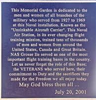
Naval Air Station, Grosse Ile
Naval Air Station Grosse Ile (abbreviated as NASGI) began development in 1927, around the same time that Wayne County Airport (the forerunner to Detroit Metro Airport) was opened. Its existence would actually predate the first development. Naval activity was taking place on the southern tip of the island as early as 1925. In the absence of any infrastructure on-site in its first year, naval officers had to make use of a floating tin hangar that was towed down the Detroit River from its original central location in Detroit.
NASGI was officially opened on September 7, 1929. Construction on the ZMC-2, a unique all-metal airship unique to the Navy, had been ongoing since 1925.
A hangar would finally be built on site to replace the towed tin hangar. This hangar remained on site until 1960 when it was dismantled, only to reappear as the building housing Belmar II bowling center in neighboring Trenton (until itself demolished by 2020).
America’s relations with other nations were solid during the 1930s; however, this peace time was tempered severely by the Great Depression. With money difficult to come by and affecting most people and businesses, little development would take place at NASGI during that time. Troop numbers, however, would continue to grow – reservists would often station there with no pay – and the first Marine detachment had established itself there in 1930. The Navy would eventually take over the entire parcel of land now comprising airport operations by 1935.
After the attack on Pearl Harbor on December 7, 1941, the United States plunged into World War II. The Navy was largely considered untested in such defense measures, as that branch had only been in existence thirty years… a relatively short time.
After the conclusion of the war, NASGI became primarily a training base, led by a fleet of A-1 Skyraiders. The airfield would officially change branches in 1956, with the Army replacing the Navy as the main training tenants. At this time, a NIKE missile site was constructed along the perimeter of East River Road south of Groh Road (the site of the present-day Grosse Ile Nature & Land Conservancy lands). The missiles stored here – D51’s – were similar to the installations seen in Riverview during that time. Also similar to Riverview’s site was Grosse Ile’s missile site closing in 1963, as it was decided not to refurbish either site with the new NIKE Hercules missile, these were placed at other installations.
A vital addition to the airfield during the early 1960s were the arrival of helicopters, led by the Piasecki H-25 (HUP-1). These proved to be very beneficial in the absence of a fully staffed Coast Guard station nearby. These assisted in many rescues around nearby Lake Erie. By that time, the facility entered its final phase as a military venue, comprising over 600 acres and numbering 2,000 reservists from the Navy and Marines. Future Secretary of State Donald Rumsfeld, representing branch VS-731 (Air Antisubmarine Squadron) would be stationed here as he flew an S2F Tracker.
The base was finally dismantled in 1969, with all units moving to Selfridge Air Base in Harrison Township as a tenant organization. Since then, Grosse Ile Municipal Airport (coding: KONZ) has maintained its presence on-island for small, non-commercial aircraft. Recent counts average approximately 24,000 takeoffs and landings yearly.
In 1997, a Township site survey for the new Township Hall would pick the old Hangar One as its permanent home, and would spend the ensuing two years housed in neighboring Hangar Two, while the old Hangar was retrofitted and modernized. The barrack buildings, which were located on the north end of Groh Road near Meridian Road, were all razed in the 1970s and the area has slowly redeveloped as part of the Airport Commerce Park.
