Obtaining food was a big challenge
Having founded Fort Pontchartrain in 1701, Antoine de La Mothe Cadillac and his initial group of settlers relied on deliveries of food supplies and other rations from the Quebec territories. The distance traveled between the two territories was virtually insurmountable, but was deemed necessary.
Due to the proximity of competing Indian tribes on all sides of the new Fort, not enough land had been appropriated to grow crops. In addition, Cadillac had not been given approval to give the go-ahead for farm establishment.
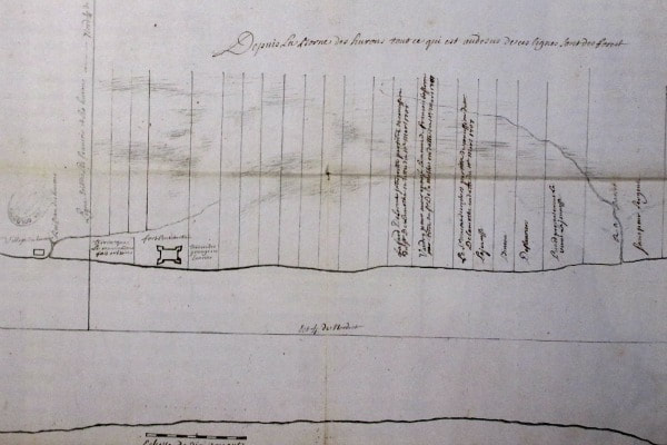
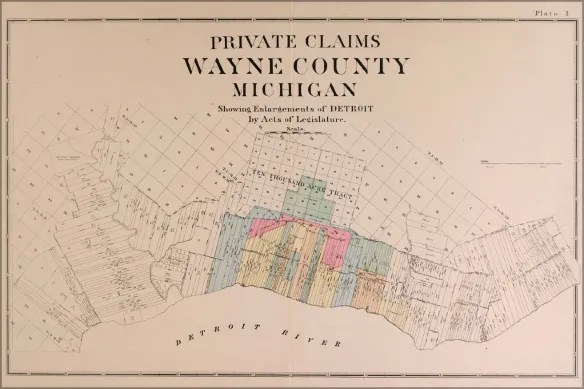
When finally able to do so in 1707, Cadillac issued a total of 31 farm grants in three years, for ribbon farms extending from Fort Pontchartrain (the future Detroit) southward toward the wooded Downriver area. Ribbon Farms are defined as long, narrow land divisions which adjoin a body of water or road. In this area, they were considered a European descent. The initial farms in Detroit, when constructed in the 1700s, averaged 250 feet wide and three miles long.
Much more was to be expected in the ensuing years, but Cadillac was “promoted” to governor of the Louisiana territory in 1710. Therefore, between that time and 1730, the Detroit colony languished, as new permits were not issued.
Once King Louis XV was in power in the early 1730s, he encouraged established colonies like Fort Pontchartrain to become more self-sufficient, and began granting permits once again in the years following the Fox Wars, which ended in 1733. The southwestern boundary of these permits appeared to be the property line of the Huron Indian establishment.
In 1738, an apparent dispute arose with the Ottawa Indian tribe, which caused the Hurons to abandon their village west of Fort Pontchartrain. This would encourage the establishment of future ribbon farms moving closer to the Downriver area near present-day Delray and River Rouge.
The takeover of Fort Detroit by the British in 1760, followed by Chief Pontiac’s actions from 1763 onward, once again halted the progress of ribbon farm construction. Farm after farm would be abandoned by their original settlers.
The influx of the white man encouraged transfer of deeds as well as redevelopment of land in the subsequent years. For example, Grosse Ile was purchased from the Potawatomi less than twenty years before the Macomb brothers signed the official deed to make Grosse Ile an eventual Township. During this space of time before the American Revolutionary War, these farms began to develop south through Downriver toward Lake Erie. In the case of areas around Delray and River Rouge, these farms began locating more inland.
Just four days before the seeds of Revolution were planted, leading chiefs of the Potowatomi Nation deeded a huge tract of land to France-born Pierre St. Cosme. That grant, dated July 1, 1776, gave him and his two sons land which included most of present-day Ecorse, Lincoln Park, Allen Park and part of Wyandotte. However. St. Cosme was unable to move forward with substantial farm development due to British control still being wielded on the new country. This was a result of the Indian still possessing the right to successfully defend themselves from encroaching members of other backgrounds.
St. Cosme, an area pioneer nonetheless, would live on for years after his 1787 death with the naming of the St. Cosme Line. This was a major east-west thoroughfare which resulted due to neighboring ribbon farms having frontage along the Rouge River, rather than the more general geographical practice of facing the Detroit River. It was sold sometime after 1787 by his wife and sons to French dwellers in Detroit and Windsor. St. Cosme Line would eventually become Southfield Road in this vicinity.
The dawning of the 1800s brought some much-needed relief to some beleaguered farmers in the area. The Detroit Land Bank opened by 1804, which made the permit process much more manageable. In addition, according to previous declarations, the area of their farms had required that a wooded area in back of their properties not be touched, possibly to act as an official, unfenced property line. Farmers were able to successfully argue that they needed to service and harvest the woodlands for fuel, fence construction, and outbuildings. The United States Congress would pass a law in 1812 granting these farmers a literal doubling of their land holdings.
Still, as late as 1818, an unofficial survey of the ribbon farms indicated very little development, as the majority were still densely forested, in spite of historical family names such as Bondie, Lafferty and Montie setting up quarters in the territory. Even with the Township Survey taking place in 1827 (resulting in the creation of Ecorse Township), there was scant initial change.
However, in the years leading up to the American Civil War in 1861-65, progress came in a flourish as the Frenchmen, joined now by German ancestry, began clearing the forests and brush for farmland development. By the 1870s, the future city of Ecorse territory became the central spot for farmers to provide their stock in trade. This would evolve into a burgeoning development in the Lincoln Park portion of the St. Cosme Line of grocery stores and other businesses.
Locally, this was the approximate time frame when many of the pioneering settlers in the Downriver area, with names such as Cicotte, Labadie, Salliotte and others began establishing their farms and families in the Downriver area. However, with the emerging industrial base having spread northward from Wyandotte, the farming industry would soon be competing for any available lands not already deeded.
